No:16 Chambre D'Hotes has been open since May 2017 but was not completed (final room) until the beginning of July, the official opening on 9th July was attended by the Mairie of Tessy and many other local guests.
From here you can discover many places to visit all within an hours drive of No:16. If you don't like the War history, then do the Famous Fashion Museum of Christian Dior or even visit the local brocante/ Troc!! A Troc is a shop or warehouse, or even an old shack along the road which sells all sorts of second hand furniture and junk. Brilliant for up cycling projects! The Happy troc is in Saint Lo and the 'La Cle des temps' in Coutance.
About a 30 minute drive from No:16 is a beach town called St Martin Brehal. Here you will have to take off your socks and shoes, roll up your jeans, take your bucket and pick up the 'Coquilles Saint Jacques' (Scallops) and mussels which are easily found on this beach!
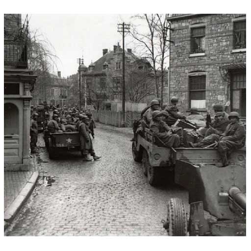
Tessy sur Vire is a small village on the outskirts of Saint Lo, it is steeped in history about the War, having been occupied by the German Secret Police until it was liberated by the Americans in 1944. If you are interested in the War, please ask Katie to give you a copy of the report from the 'Battle of Tessy' and local photographs of the town in 1944. In addition Katie has in her possession her uncle's letters home during WW2, they are very precious to the family who have agreed that they should be here at No:16 for other enthusiasts to read. (ask Katie to view).
In 2016 Tessy had the privilege of being on the Tour de France route and there are some great cycle rides along the River Tessy and going far afield, you can hire a bike from No:16. The river is also good for fishing! (you need to buy a permit)
To view the beautiful Gorge, a must to visit is Roches de Ham only 15 minutes from NO:16
Close by is Moyen, where there is a chocolate factory and they do tours on a Thursday morning. They also have a shop on site which is open most days.
Saint Lo is about 14km away, a walled city, it is a large spread out town, with lots of small shops and patisseries! It hosts a farmers market on Friday and Saturday mornings, which is excellent, fresh fish, cheese and dairy from the local farms etc. On Saturdays there is also a mix of flowers, plants, clothes and bric a brac. The 'Zone Industriel' is at Agneaux and there are a lot of large shops etc. St Lo is also very famous for the Haras National Horse shows, and sales, there is a small museum in Stable 5 which also houses exhibitions and has many of the coaches and carriages pulled by the horses in the very early 19th century. Funnily enough, many of the coachworks were in fact English!
If you want a shopping Mall, then MONDEVILLE at Caen is probably the biggest in the area, but it is not a closed in Mall, it is more of a very large precinct. Caen also is home to the newest WWII Museum.
Hambye is 14km on the D13, it is a straight road and has the most beautiful Abbey Ruins I have ever seen, when it is lit up at night it is stunning as you drive into Hambye.
Granville is famous for it's March Carnival and the harbour where you can take a day trip to the channel Islands or visit the famous Christian Dior musieum.
At Coutance is the 'Dead Mans Corner' and the D Day Experience museum which has an original US ditched plane which is now a simulator for you to experience flying amongst a dog fight! this museum has recently opened a new 3D cinema which is excellent and shows how the Americans were trapped at Coutances by the Germans and how the British came in from the rear of the Germans where they were unprepared for attack. This allowed the Americans and British soldiers to defeat the Germans and to carry on through Normandy to liberate the occupied towns. When you watch this film, you are actually sitting in the same place that this attack took place! (This is my favourite museum!) This is a short drive onto St Mere Englise where you will find the Paratrooper still swinging from the Church Spire! there is a good museum here too. The next drive on takes you to the Pont de Hoc where you can go to the battlements and see where the German guns were waiting for the troops to land on the beaches, then next is Utar & Omaha American Landing Beaches with several good museums and tank museum. driving on along the cost you then come to Aromanches which was the British landing beach of 'Gold' the next 2 beaches are Sword and Juno which were Canadian and British landing beaches.
If you are energetic!!! there is close by River Kayaking, Bungee jumping and zip wires and a fabulous outdoor centre at the Viaduct. Throughout the months of June to September every village has it's own festival of music and you can go and take a beer and have the French Sausage and Fritze (chips). These festivals are all Free!
There is so much to do and see within an hour of No:16
Please ask for further information on the local area. In each room in the centre draw of the dressing table are leaflets of the areas and things that are on.

Address: 2, Amont Village, 50500 Saint Côme du Mont
Phone: +33 2 33 23 61 95
DEAD MAN'S CORNER : located at the heart of history
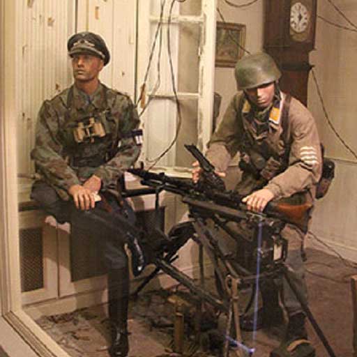
Headquarters of the German paratroopers before being taken over by the American paratroopers, it is currently a museum dedicated to the former. Discover the story of this house which holds a unique and authentic collection of artifacts.
Here, the men of the 6th German parachute infantry regiment (PIR) nicknamed the 'Green Devils' fought fiercely for three days against the American paratroopers of the 101st Airborne Division. On the morning of June 6 1944, the Commander of the German paratroopers, the major von der Heydte established his headquarters whereas the Dr Roos set up an aid station.
On June 8, as the Germans withdrew to Carentan the American Colonel “Iron Mike” Michaelis established the headquarters of his unit, the 502nd PIR of the 101st Airborne.
But why this strange name?
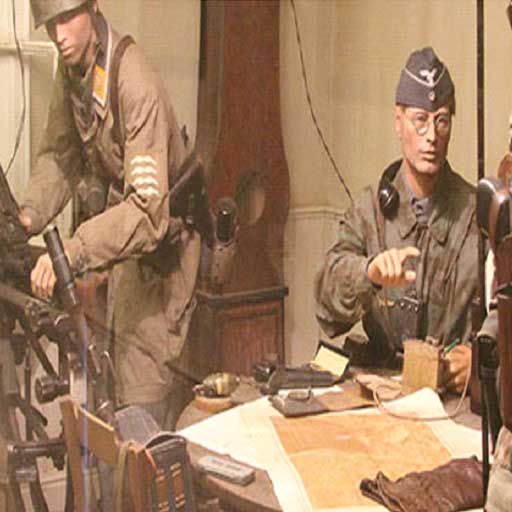
In the village, it is said that the house is haunted! Some feel wandering souls there. Others feel uneasy due to the catchy reenactment. Through authentic artifacts that belonged to German paratroopers you will discover the strategic challenge with the city of Carentan and why this Dead Man’s Corner was so crucial during the seizure of this city. By visiting this place, you will step into history, learn more about both the meaning of this name and the men who fought at this very place.
What if the artifacts could speak?
The 'Green Devils' are waiting for you.
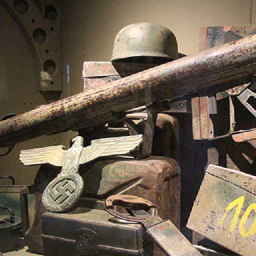
As you enter this famous house in which the bloodshed took place, you will be engrossed in the atmosphere of the very first moments of the landings as lived by the Germans. The events that took place here have been carefully recreated by the means of authentic artifacts to get you immersed at the core of history. Said artifacts were recovered from the ground for a large part of them and have shaped history. And their story is told by the very eyes of Major von der Heydte.
D DAY LANDING BEACHES
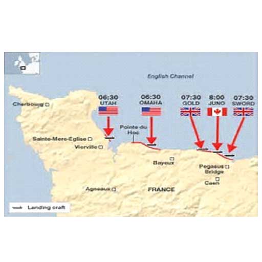
Early in the morning on June 6, 1944, about 156,000 Allied soldiers stormed a handful of beaches along the coast of Normandy, France. Although choppy seas and heavy German resistance prevented them from fully meeting their objectives that day, they were able to gain a crucial foothold. By late August, Paris had been liberated, and Germany’s surrender came not long afterward. On D-Day’s anniversary, take a look back at the two American, one Canadian and two British landing points that kicked off the Allied invasion of Western Europe during World War II.
Utah Beach
The westernmost of the D-Day beaches, Utah was added to the invasion plans at the eleventh hour so that the Allies would be within striking distance of the port city of Cherbourg. In the predawn darkness of June 6, thousands of U.S. paratroopers dropped inland behind enemy lines. Weighed down by their heavy equipment, many drowned in the flooded marshlands at the rear of the beach, and others were shot out of the sky by enemy fire. One even hung from a church steeple for two hours before being captured. Those who landed, meanwhile, often found themselves outside of their designated drop zones. Forced to improvise, they nonetheless succeeded in seizing the four causeways that served as the beach’s only exit points. On Utah itself, U.S. forces landed more than a mile away from their intended destination, due in part to strong currents. Luckily for them, this area was actually less well protected. “We’ll start the war from here!” U.S. Brigadier General Theodore Roosevelt Jr., the son of former President Theodore Roosevelt, shouted upon realizing the mistake. By noon, his men had linked up with some of the paratroopers, and by day’s end they had advanced four miles inland, suffering relatively few casualties in the process.
Omaha Beach
Surrounded by steep cliffs and heavily defended, Omaha was the bloodiest of the D-Day beaches, with roughly 2,400 U.S. troops turning up dead, wounded or missing. The troubles for the Americans began early on, when Army intelligence underestimated the number of German soldiers in the area. To make matters worse, an aerial bombardment did little damage to the strongly fortified German positions, rough surf wreaked havoc with the Allied landing craft and only two of 29 amphibious tanks launched at sea managed to reach the shore. U.S. infantrymen in the initial waves of the attack were then gunned down in mass by German machine-gun fire. The carnage became so severe that U.S. Lieutenant General Omar Bradley considered abandoning the entire operation. Slowly but surely, however, his men began making it across the beach to the relative safety of the seawall at the foot of the bluffs and then up the bluffs themselves. Assistance came from a group of Army Rangers who scaled a massive promontory between Omaha and Utah to take out artillery pieces stashed in an orchard, and from U.S. warships that moved perilously close to shore to fire shells at the German fortifications. By nightfall, the Americans had carved out a tenuous toehold about 1.5 miles deep.
Gold Beach
Owing to the direction of the tides, British troops began storming Gold, the middle of the five D-Day beaches, nearly an hour after fighting got underway at Utah and Omaha. The Germans initially put up robust resistance, but in sharp contrast to Omaha, an earlier aerial bombardment had wiped out much of their defenses. British warships also proved effective. The cruiser HMS Ajax, for example, displayed such pinpoint accuracy from miles away that it apparently sent one shell through a small slot in a German artillery battery’s concrete exterior—the military equivalent of a hole-in-one. On shore, meanwhile, armored vehicles known as “Funnies” cleared away minefields and other obstacles. Within an hour, the British had secured a few beach exits, and from there they rapidly pushed inland. They also captured the fishing village of Arromanches, which days later became the site of an artificial harbor used by the Allies to unload supplies.
Juno Beach
At Juno, Allied landing craft once again struggled with rough seas, along with offshore shoals and enemy mines. Upon finally disembarking, Canadian soldiers were then cut down in droves by Germans firing from seaside houses and bunkers. The first hour was particularly brutal, with a casualty rate approaching 50 percent for the leading assault teams. In the confusion, an Allied tank inadvertently ran over some of the wounded, stopping only when a Canadian captain blew its track off with a grenade. Other Canadians lacked any tank support at all. After fighting their way off the beach, however, German resistance slowed immensely, and the march into the interior went quickly. In fact, the Canadians advanced further inland than either their American or British counterparts. Though they didn’t quite meet their objective of taking Carpiquet airport, they captured several towns and linked up with the British on adjacent Gold Beach.
Sword Beach
Around midnight, British airborne troops, along with a battalion of Canadians, dropped behind enemy lines to secure the invasion’s eastern flank, just as the Americans were doing near Utah. Within minutes, they had taken hold of Pegasus Bridge over the Caen Canal and nearby Horsa Bridge over the River Orne. Other airborne troops destroyed bridges over the River Dives to prevent German reinforcements from arriving, and they also took out a key German artillery battery in a bloody firefight. The British then landed on Sword at 7:25 a.m., around the same time as at Gold but before Juno. Although moderate fire greeted them, they soon secured beach exits with the help of the “Funnies.” Moving inland, they connected with the airborne units but faced relatively strong resistance in farmyards and villages. In a late afternoon counterattack, German forces made it all the way to the beach in one location, only to be turned back. The Allies would not be able to unite all five D-Day beaches until June 12.
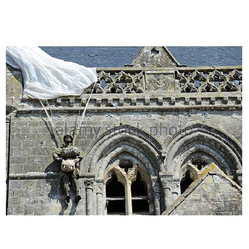
Don't Forget to go to St Mere Eglise
The Germans took St Mere Eglise on June 18th 1940 and the next four years passed relatively peacefully, soldiers were billeted in the town and a swastika flew over the town hall. During 1943 the number and quality of the occupying troops decreased. By the time of D-day the town was occupied by Austrian anti aircraft gunners, driving wood burning trucks. During 1944 there were frequent allied air raids on the town and the night of June 5th - 6th was no different. A house in the square caught fire, (now the site of the airborne museum) possibly caused by one of the marker flares dropped by the pathfinders. The inhabitants formed a chain with buckets from the pump in the square (now a listed monument). At this point parachutes were seen in the night sky and began landing in and around the town. It was the 82nd airborne division. The Germans opened fire and ordered the locals into their houses. The Austrians left and only a few Germans continued the fight. The town was taken by members of the 505th led by Lieutenant-Colonel Edward C. Krause. At 04:30 the stars and stripes were hoisted over the town and St Mere Eglise was the first town to be liberated in France.
The town was made famous by the paratrooper John Steel and by the film "The Longest Day". John Steel managed to land on the church and his chute caught on the steeple. He hung there while the fighting continued on the ground for two hours before being cut down by the Germans, taken prisoner and later released by the Americans. An effigy of John Steel is usually to be seen on the church. Inside the church there are two stained glass windows, one shows the Virgin Mary surrounded by paratroopers, the other shows St. Michael (patron saint of the paratroopers) and was dedicated in 1972. The liberation monument in the square was covered by a chute during the making of The Longest Day as the town mayor would not allow its removal.
The Airborne Museum began in 1961, houses many interesting artifacts including a DC3 aircraft used on D-day together with a glider. Outside the Town Hall is a pink marker stone of "Kilometre Zero". These markers were placed by the French Government in 1946, each Kilometre along the route taken by General Leclerc’s Free French 2nd division, they can be seen from North Africa to the town of Bastogne the last town in Europe to be liberated. The town war memorial is situated behind the marker and plaques commemorate the liberation of the town. There is also a plaque to the Generals Ridgeway and Gavin and all the liberators. In the town hall are the Stars and Stripes, flown over the town on the day of liberation, it was also flown at Naples in 1943 when it too was liberated. It was brought to Normandy by Lieutenant-Colonel Edward C. Krause. It was given to the town by his widow on his death. You may be confused when we get to Utah beach to find another Kilometre marker showing KM00. It is due to the rival claims made by both the communities, here and at St Marie du Mont, which was the first village to be liberated by troops landing by sea. You will find there are many claims to the "the first" in this part of France. Fighting continued around the town until the afternoon of June 7th when tanks landed at Utah arrived and secured the area.
Arromanches
No other port is more closely linked with the liberation of Western Europe after D-Day. Along with the staggeringly big concrete blocks remaining from the Mulberry Harbour towed over from Britain in June 1944, war museums bring the massive Allied operations here back to life. But Arromanches is also an appealing resort today
D-Day, A portable harbour
Arromanches is a very moving place. Here, in the midst of the D-Day beaches, you still get a strong sense of the huge effort involved in the Allied invasion to liberate France and the rest of Western Europe from June 1944 on. Troops deliberately did not land at Arromanches on D-Day itself, to leave the coast here clear for a portable harbour (nicknamed Mulberry Harbour) being tugged over from southern England to be put in place, free of any debris.
The port was meant to be temporary, lasting maybe three months. It served for some five months. The Arromanches Mulberry Harbour became known as Port Winston, after British wartime leader Winston Churchill, who was closely involved in its conception. A staggering 2.5 million men, 500,000 vehicles and 4 million tonnes of supplies arrived via Port Winston.
Despite all its sombre reminders of the shattering war effort, Arromanches has a good deal of charm, offering wonderful beach and cliff walks. Wandering around the port, you can also spot some intriguing memorials.
Must-sees, What to see in Arromanches
D-Day Museum - Musée du Débarquement: this central museum focuses on the D-Day landings and the crucial months of Allied action afterwards. It goes into fascinating detail about the setting up of the Mulberry Harbour here via models and displays. There are also powerful videos to view.
Arromanches 360°: images bombard you from all sides in this circular cinema opened for the 50th anniversary of the D-Day landings. The clips take you racing through the 100 days of the Battle of Normandy to liberate the region before the Allies moved on to free the rest of Europe from Nazi occupation.
Memorials to British Sappers: poignant memorials to British engineers, or sappers, can be seen around Arromanches. These sappers played a critical role in preparations leading to D-Day. On the heights east of town, beside an unmissable statue of the Virgin Mary, a memorial honours the sappers of the Royal Engineers. Down in town, a memorial from 2009 pays homage to the brilliant London engineer, Allan Beckett. His design for a floating roadway was of great significance, allowing Allied craft to land safely. Near Beckett’s memorial, a so-called ‘whale pier bridge’ used by disembarking Allied craft is on display.
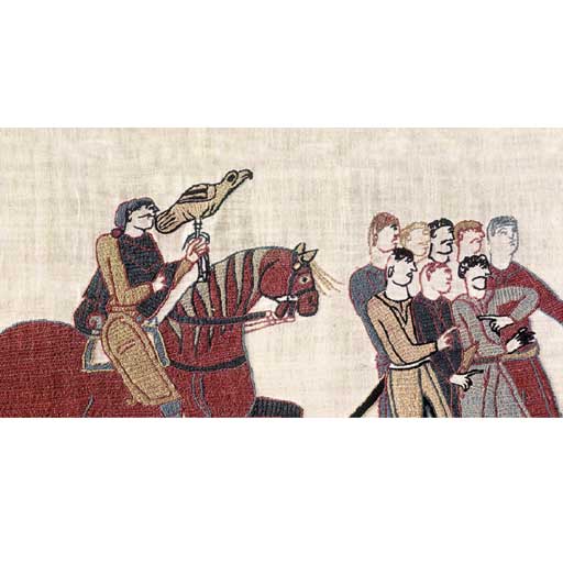
Bayeux Tapestry
Adresse
13 bis rue de Nesmond
14400 Bayeux - France
Téléphone
33 (0)2 31 51 25 50
The story of the Norman Conquest of England in 1066, as least as seen from the Norman side, is depicted in this unique object, the Bayeux Tapestry. Although more than 900 years old, its images are still gripping. It is a coloured embroidery, 70 metres long, full of vivid action, and also much that is unexplained and enigmatic.
There are short running captions in Latin and a wealth of fantastic activity in the upper and lower margins. The heart of the story is the struggle between duke William of Normandy and Harold Godwinsoin to succeed Edward the Confessor as king of England.
It was clearly designed by an artist capable of detailed and close observation. For example, the Tapestry shows how Normans and English could be identified immediately by their haircuts. The English have shoulder-length hair and moustaches but no beards, while the Normans are clean-shaven and have their hair razor-cut dramatically high at the back.
In Anglo-Saxon England it was only the priests who were fully clean shaven. This explains the legendary story that, when King Harold's scouts first saw the Normans camped outside Hastings, they reported back that "they have sent an army of priests!"
William of Normandy never accepted that Harold was a rightful king. As one French chronicler put it, Harold was only a "pseudo-king". The Bayeux Tapestry tells the story from this point of view.
The first half of the Tapestry is devoted to a journey that Harold took to France, where William is shown treating him honourably and fairly, and Harold is depicted swearing an oath to William on holy relics. It can be assumed that this oath involved a promise to support William's claim to the kingship of England.
Not long after Harold's return to England, according to the story in the Tapestry, he perjures himself in a spectacular way, disregarding his oath and seizing the throne for himself.
Nature itself is disturbed by this wickedness. In February 1066, after Harold had been on the throne less than two months, a comet appeared in the sky (we now know this as Halley's comet). For the people of the Middle Ages, the appearance of a comet meant some great change was about to occur, perhaps the downfall of a regime. This was why, in this period, a comet was called "the terror of kings".
And Harold had reason to fear. The Tapestry shows Duke William making his preparations: building a fleet, gathering supplies, and mustering troops. William's fleet, with its dragon-headed ships reminding us of the Normans' Viking ancestry, is shown sailing the 70 miles to the Sussex coast.
Once landed, the Normans began as they meant to continue, building two castles within a fortnight, one at Pevensey, one at Hastings, and ravaging the surrounding countryside. The Tapestry shows a woman and her child fleeing a burning house. The Godwinson family had its origins in Sussex, so Harold had been challenged on his own ground.
The Tapestry's depiction of the Battle of Hastings is the fullest pictorial record of a medieval battle in existence. The English occupied the ridge, standing shoulder to shoulder, many armed with huge axes and protected by their large oval shields. They were on foot. English aristocrats certainly rode, and used horses to get to the scene of battle, but they were not trained in cavalry warfare.
Fighting began about nine o'clock on that October day. The first attack of the Normans was repulsed, and some of the English chased them down the hill. A rumour spread that duke William himself had been killed. As the Tapestry's illustration shows, he pulled off his helmet to reveal his face, and cried out, "I live, and with God's help will conquer yet!" His men rallied and killed the English who had followed them down.
Having seen what happened when the English broke ranks to pursue them, the Normans now tried the same thing on purpose, pretending to retreat in order to lure the English into a more vulnerable position, where the Norman cavalry could cut them down.
The battle went on all day. The Tapestry shows the confusion and desperation of the fighting. The captions identify Odo, bishop of Bayeux, half-brother of William the Conqueror, deep in the battle. Because he was a bishop, he was forbidden to shed blood, so, instead of a sword or lance, he carries a huge club. That way he could break a few arms or heads without any bloodshed.
The caption above him explains what he is doing "Here bishop Odo, holding his club, encourages the boys". Many people think that it was Odo who ordered the Tapestry to be made, hence his prominent position in the story.
The decisive moment in the battle was the death of Harold. Two early accounts of the battle say that the king was struck in the eye by an arrow. There has been long debate about whether the image in the Tapestry shows such a scene.
The words "Here King Harold has been killed" run along the top of the Tapestry, but do they apply to the figure directly below or to the man on the right being cut down by a Norman horseman? And, indeed, is the arrow in the eye really an original feature of the Tapestry, or a piece of guesswork restoration from the long centuries between the creation of the Tapestry and modern times?
Intriguing though such questions are, what really mattered on 14 October 1066 was that the king - along with his two brothers - was dead. The English fled, pursued by the victorious Normans. Next day William set off on the march to London, where, on Christmas Day, he was crowned King of the English in Westminster Abbey, the glorious new church that had been the scene of Harold's coronation less than twelve months before. The end of the Tapestry is lost but a good guess is that its final scene was this triumphant coronation of the Conqueror.
While in Bayeux, you really should cross the road and visit the Cathederal!
Construction of Bayeux Cathedral began in the Roman period, under Bishop Hugues, to continue under William the Conqueror's brother, Bishop Odo (11th Century). Following serious fire damage during the 12th Century, the cathedral was rebuilt in Gothic style in the 13th Century. Construction of the central tower began in the 15th Century, under Bishop Louis d'Harcourt, to be completed only in the 19th Century following major work by Eugène Flachat. discover of one of France's finest cathedrals and an indisputable masterpiece of Norman Gothic art.
Christian Dior Museum
Granville
Progressively, the idea of turning the villa “les Rhumbs” into a place dedicated to Christian Dior’s memory became a real project, driven by the curator Jean-Luc Dufresne, the couturier’s little cousin.
In 1987, the exhibition “Christian Dior, the other himself” at the Richard Anacréon modern art Museum, in Granville, led to the creation of a collection, first composed of donations from Christian Dior’s close relations, most of all from his two sisters, Catherine and Jacqueline, and from partners. Then, the curator added items purchased by the town of Granville.
From 1991, year of creation of the association “Présence de Christian Dior”, the constructions were made gradually. Until 1995, the town of Granville was in charge of the acquisitions while the association was working on donations. Since 1995, the association “Présence de Christian Dior” heads the acquisitions with the help of Dior Couture and Dior Perfumes – and also the help of the LVMH company, of the town of Granville, and of the regional acquisition fund for the museums. In 1997, the creation of “showcase rooms” allowed the museum to show models and accessories in the best conditions and to open regularly the villa to the public.
The centenary of the couturier’s birth, in 2005, was the perfect time for big transformations and then for the memorable exhibition “Christian Dior, man of the century”, recognized as being of national interest.
Currently headed by Jean-Paul Claverie, the LVMH director’s counsellor, the association manages the Museum and drives the cultural and scientific project through public service delegation of the town of Granville. It benefits from the support of public partners – town, departments, regions, State – and private individuals associated as sponsors – Dior, LVMH. The walls and the collections of the museum belong to the town of Granville, the financing and the managing of its business are handled by the association. Preserving the inalienable collections, enriching them thanks to an active policy of acquisitions, and introducing the work of Christian Dior through exhibitions and cultural events organized in the villa Les Rhumbs constitute the essential task of the association.
The Christian Dior Museum is the only “Musée de France” dedicated to a couturier. Since 2010, in addition to an annual thematic exhibition, it organizes an autumn-winter exhibition, “Une maison, des collections”, showing its permanent collections and its most recent acquisitions. In June 2012, it obtained the “Maison des Illustres” label from the Ministry of Culture.
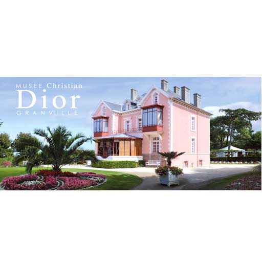
Villa les Rhumbs
Rue d'Estouteville
50400 Granville
Mont Saint Michel
Apart from monuments in and around Paris, Mont Saint Michel is the most visited tourist attraction in France. And it is not difficult to see why. This remarkable mediaeval walled city, crowned by its great gothic abbey, is built on a small granite outcrop standing all by itself in the flats of the estuary of the river Couesnon, in an area now known as Mont Saint Michel bay. Mont Saint Michel was one of the first monuments to be classed as a UNESCO world heritage site, as far as 1979.
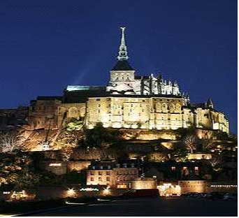
Le Mont Saint Michel is not just a church on a rock; it is a whole mediaeval city, one of the few places in France to have preserved intact its mediaeval walls and defences. The city, though small, has to this day inhabitants - not many full time inhabitants - and a mayor, and in addition to its religious monuments, has old houses, narrow streets, hotels, restaurants and shops, all catering for the over-a-million tourists who come to visit this magnificent site each year.
The first Christian oratory was founded on the island as far back as 708 AD, by Saint Aubert of Avranches, and naturally it was dedicated to Saint Michael, the patron saint of sailors. In those days, and for the ensuing centuries, the island of Saint Michel was a proper island out in the bay, surrounded by water for much of the time and by sand at low tide. Access was by boat or across the sand when possible. However, over the course of the centuries, as the bay gradually silted up, the shores got closer and closer to the mount. The process was accelerated by successful attempts over the years to reclaim some of the flat fertile wetlands at the edge of the bay, for use as agricultural land. Mont Saint Michel bay is thus now several square miles smaller than it was in the Middle ages, when the first Benedictine monastery was set up on the island.
During the Middle Ages, le Mont Saint Michel was an important and iconic location in this north western part of Europe . Its monastery flourished as one of the great places of learning in the twelfth century, before becoming a place of symbolic importance in the struggles that convulsed western Europe in the late mediaeval period, pitting Normans against Bretons, French against Normans, and French against English.
As part of Normandy, the Mount belonged to the successors of William the Conqueror, the Duke of Normandy who had conquered England in 1066 and set up his court there. Normandy, and with it the Mount, had thus become an English possession, just as the nearby Channel Islands (known in French as the Anglo-Norman isles) remain to this day.
The town was captured and burned down by the French in 1204, who then proceeded to rebuild it. Later, during the Hundred Years' War, it was besieged by the English, but not recaptured.
The Abbey that most visitors climb up to see is a fine example of mediaeval architecture, different parts dating from different periods as is common in old cathedrals and abbeys, particularly those that have experienced wars and natural disasters. The impressive gothic choir dates from the period following the departure of the English. However, like much of the building it was seriously and extensively renovated in the nineteenth century following a visit by France's great gothic revivalist architect Viollet Leduc. Thus it was that in 1896, the Abbey became crowned by its landmark spire, which is not mediaeval at all, but the work of the architect Edouard Corroyer.
By that time, the Mount had already been classed as a historic monument, and was beginning to attract tourists, for whose benefit an insumbersible causeway had been built in 1880. But the effect of the causeway and other land management schemes - as well as bringing increasing numbers of tourists to the mount - was to considerably accelerate the silting up of the bay, to the point at which there was a serious risk that the Mount would before long be landlocked if nothing was done.
Since the nineteen-eighties, measures have thus been undertaken to dredge the bay and put the process of silting into reverse, in order to return the Mont Saint Michel to what it once was, a small granite island in the bay.
Tides: the Baie de Mont Saint Michel is one of the most steeply tidal points in Europe, with a tidal variation of almost 50 ft or 15 metres. The highest tides (spring tides) occur in the day or two following a new moon and a full moon, and most particularly at the spring and autumn equinoxes. On these occasions, the sea can completely surround the mount, except for the insubmersible causeway. During periods of neap tides (when the tidal variation is least) the Mount is not surrounded by water at all, even at high tide.
Listed below are the market days for the Manche department: